 |
 |
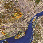
Satellite image of Montréal |
||||||||||||||||||||||||||||||||||||||
| Home > Academic > Urban Planning | ||||||||||||||||||||||||||||||||||||||||
|
Graduate studies and research Currently, I am doing my graduate studies in the School of Urban Planning of McGill University. The topic of my thesis is "Feasibility Analysis of Conversion, Modernization and Reutilization of Underused Rail Facilities for Public Transit in Montréal". I am working under the supervision of Professor Murtaza Haider (PhD candidate, University of Toronto). My project is supported by the Bourses du ministère des Transports, administered by Le fond de recherche sur la nature et les technologies (formerly known as FCAR).  Here is the description of my research: There exists a large amount of railroad tracks spread across the Island of Montréal and its surrounding. Some of the tracks have limited use nowadays. However, their value could be greatly enhanced if they were properly reintegrated into the transportation system. To build new public transit infrastructure in an already developed urban area is often expensive and difficult, if not impossible. Buildings along major arterials would have to be demolished in order to retrofit a transit system. Through modernization and/or conversion of the railroad tracks to support another use such as a light rail transit, they could not only supply new public transit service at a reduced construction cost, but also increase land value, stimulate construction on old industrial land and reduce automobile use in the new transit corridors. The goal of the research is to identify and carry out a preliminary study of the potential tracks that could be modernized, converted and reutilized for public transit. Since there are many railroad tracks in Montréal, first we have to select those which are suitable for redevelopment. Information will be gathered from various organizations such as the federal and provincial governments, the Agence Métropolitaine de Transport (AMT), the City of Montréal and surrounding cities, and railroad companies to identify the underused tracks. With data from the Origin-Destination survey collected by the AMT, we can use transportation geographic information systems (GIS), such as TransCAD, and models to perform analysis. By finding out where trips are produced and attracted, their purpose and the mode used, we can evaluate each of the potential tracks and identify the possible location of new stations and modal interchange points. Once the potential tracks are selected, we can study the necessary adaptations, changes and additions to make to the tracks and propose possible new land uses in areas adjacent to the tracks. Since the tracks are owned by railroad companies, cooperation between them and different levels of government is required. Although the tracks may be underused, they may still be occasionally used for freight transport. This study will also explore the arrangements that can be made to satisfy both uses. Relevance to the ministère des Transports Montréal is the most important economic centre in Québec. As the city grows, trips within the city also increase. Over the years, major developments occurred in the city. Previously undeveloped locations have become major trip origins and destinations, such as the Bois-Franc residential development, the Technoparc of Saint-Laurent, which is a key employment centre, and the Marché Central, which has become a popular shopping area. New public transit facilities are required to serve them. Otherwise, dependence on the automobile will lead to traffic congestion, increased travel time and energy use, poorer air quality, and ultimately economic loss. Therefore, my proposed research aims to examine the potential of providing new and efficient public transit service by reutilizing the underused railroad tracks. It ensures that people who depend on transit will be able to reach major destinations efficiently and reliably and at the same time, offers an alternative to automobile users. Currently, the Ministry of Transport is analyzing some future plans in transportation, such as an east-west transit corridor along the Autoroute Métropolitaine (A-40), extension of the métro in Saint-Laurent Borough, and a rail connection between downtown and the Dorval Airport. My project will take these plans into consideration and analyze the possibility of using existing railroad tracks to meet those needs. At a preliminary glance, the railroad tracks located north of the A-40 between Saint-Laurent and Anjou and along A-20 between Downtown and Dorval Airport seem to be potential candidates for redevelopment. We will evaluate the possibility of converting the track along A-40 into light rail transit. It passes through major destinations such as the Marché Central, the Cité de la mode, Village Montpellier and two Cégeps. With extensions to the track, it can connect the Technoparc of Saint-Laurent and the Galerie d'Anjou. In order to integrate the new transit corridor into the existing system, modal interchange can be put at Du Collège and Sauvé métro stations and Montpellier train station. Since it is a tangential line serving suburban areas, it is important to carefully study the demand and the current proportion of work trips using transit in those areas. This can be done using transportation models with the data from the Origin-Destination survey collected by the AMT. It is also important to know that how accessibility and parking ease (Métropark) affect the level of transit use. This way, we can improve the accessibility of the stations in order to attract more users. The track along A-20 can be used as an airport express line to connect Downtown. It will facilitate travelers and employees going to the airport. Currently, public transit connection to Dorval Airport is very weak. In sum, by providing new findings and the potential of the underused rail facilities, the research will help the Ministry of Transport to make appropriate decisions in order to solve transportation problems. GIS in Planning For the 409-505B GIS in Planning course project, I have done a small project assessing the usage of the commuter train stations in West Island. You can view my report here. What is planning? Planning is a systematic, creative way to influence and respond to a wide variety of changes occurring in a neighborhood, in a city, in an entire region, or around the world. Planners assist communities to formulate plans and policies to meet their social economic, economic, environmental, and cultural needs in the face of societal forces. Planners do so by identifying problems and opportunities, evaluating alternative solutions or plans, and communicating their findings in ways that allow citizens and public officials to make knowledgeable choices about the future. Planning can: - preserve and enhance quality-of-life - protect the physical and natural environment - promote equitable economic growth - distribute services to disadvantaged communities - respond effectively to development of all kinds What do planners do? Below are brief descriptions of the most common types of planning practice. While most planners work in the following areas, planning is such a diverse filed that you can find urban and regional planners involved in almost any government or private activity which involves a future orientation, or community change and growth. Note, too, that many kinds of planning practice overlap or are strongly interconnected. Land Use Planning Most planners are involved in this, the most traditional form of urban and regional planning. There are many different kinds of land use planning jobs. Some land use planners work on long range comprehensive plans which attempt to coordinate all the important activities engaged in by a community - housing, recreation, infrastructure, transportation, water quality, and so forth. Some land use planners develop or administer local regulations which establish the kind of housing and industrial and retail facilities which can be built in a city. Others evaluate the impact of different kinds of growth and help communities deal with the costs and benefits of proposed residential and commercial development. Still other land use planners work to protect open space and agricultural land in the face of increasing demands for new homes and businesses. Environmental Planning Environmental planners work to enhance natural resources and to minimize the adverse environmental impact of development. Some environmental planners develop expertise in one aspect of natural resource management, such as achieving clean water or preserving sensitive areas like wetlands. Other environmental planners attempt to identify the range of environmental impacts which can arise from governmental policies, or proposed land use changes, or the actions of private firms and developers. Many environmental planners work to integrate a concern about pollution and the conservation of natural resources into the plans developed in other substantive areas like transportation or economic development. Economic Development Planning Economic development planners, in the US and internationally, work to improve a community or region by increasing or enhancing economic activity. Many do so by helping develop plans which attract new businesses, creating new jobs and additional tax revenues; others work to keep business from leaving distressed areas. Some development planners promote projects which bring housing and commercial enterprises, as well as jobs, into poor neighborhoods. Some economic development planners help communities find ways to finance the cost of new development while others work to overcome regulatory and other barriers to new projects. These planners often work in conjunction with land use, housing, social and community development planners. Transportation Planning Housing, Social, and Community Development Planning Source: Choosing a Career in Urban and Regional
Planning. Association of Collegiate Schools of Planning. |
|
||||||||||||||||||||||||||||||||||||||